The Three Peaks Revisited: Settle to Ingleton Triangle (Part One)
Where on earth have you been? That has been the message from many far and wide. Almost two years since a post? What's going on? Well - I'm not dead - you'll be glad to know. I've been engaged in producing the Ingleborough Rocks website for the National Park, recovering from an annoying illness (bit by bit) and, after seeing my three fledglings flee the nest - wallowing in empty nest syndrome and all that goes with it, as well as looking after two elderly parents with their own problems. Such is life, but anyway - back to basics. This week I re-acquainted myself with the Three Peaks. Unable to do a monster walk - I eased back in gradually with a pensioner's type outing in the trusty brum brum round the 'triangle' that makes up the roads around Ingleborough. You know how it is ... I felt like a newcomer - so if you are on holiday up here in the good old north and experiencing your first peek at the big three, and the weather's naff - follow me on this adventure for your first mouthful of the Dales. If you enjoy it - you might even want to read my book 'A Three Peaks Up and Under' or even explore the rocky stuff on the Dales Rocks website ...
Where better to start than good old Settle? This is my favourite town in the whole of England. It has a maze of lovely passages and great architecture, as well as being surrounded by a landscape where meeting a T Rex would seem quite possible. The food at the Naked Man is worth a trip from the south coast - especially the Yorkshire puds. This, by the way, is the Town Hall, seen through the Naked Man window with a mouthful of millionaire's shortbread and a brew. George Webster of Kendall, its designer, must have been a clever bloke. It was built in 1832 when there was a bit of a gothic revival in Settle.
Oh, I almost forgot. When you park up and go for a first wee - there's this lovely sign on the side of the ladies' toilets. Just be careful when taking a picture, because you know what this world is like. I didn't half get some strange looks. Anyway, to the lady who scowled at me, it's nothing more than this, love. I do wish they would put it in a more dignified spot!
This is the finest building in Settle. The Folly - which was first introduced to me years ago by Mr Wainwright. Built in about 1675 - I bet it's 'wick' with ghostly goings on, as they say here in Lancashire, and I certainly wouldn't like to walk in there at midnight.
It's countenance is rather beautiful though. There was a rumour it was called the Folly as Richard Preston, it's builder, 'ran out of brass' before completing it, but that has been said to be far fetched as he was rolling in it, apparently. Maybe it's because no use was found for the building for years and years. These days it's a wonderful museum.
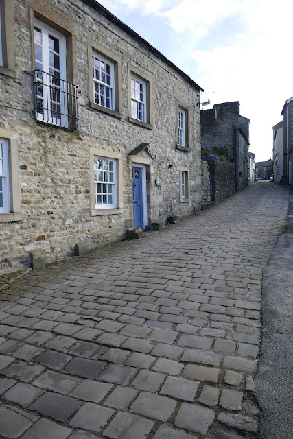
Upper Settle is reached by walking beyond the Folly. It's like stepping back into a long lost era.
Even today you can snap a picture or two with very little sign of metal boxes on wheels.
Albert Hill was renamed in Victorian times - probably linked to the exploration of Victoria and Albert caves after their discovery in 1838.
This area, known as the Green - is like a separate village in itself.
No matter where you wander in Settle, antiquity is with you. That's why I love it.
The best place name? Why it's got to be Constitution Hill!
There are many yards to peep into - almost biblical to look at.
Peeping into the Shambles: not as famous as the York version, but every bit as fascinating. It was originally a market hall with barrel vaulted cellars, being built around the same time as the Folly. A slaughter house and many butchers' shops once occupied the building. Thankfully today's usage is much more pleasant.
Only trouble is - you can never get a picture without a brum brum.
The architecture is something to marvel at, though.
The great rock of Castleberg dominates the town. Here, limestone downthrown by the Mid Craven Fault has had its covering layers of younger rocks removed by erosion, and the rock itself has been 'trimmed' off by glaciation to leave the stark object we see today. There are many climbing routes up it and the view from the top is sensational. I'll take you up in a later post as it deserves full attention.
This also deserves full attention - and usually gets it from me. The right hand side of the Naked Man was built as an inn - round about 1663. The figure on the wall above the door is not in fact 'in the altogether.' The name is believed to be a satire on men's clotthing styles of the period - when they were anything but naked and it might have taken an hour to undress - let alone have a wee!
The left hand section probably dates from the early 19th century. If you go in - get the gravy filled Yorkshire puddings. They are addictive. Not a good place if you want to lose weight. Go in before a walk - and not after. I've been known to fall asleep in here.
Whether dressed or not - he holds the date where he might have been expected to hold it in 1663. For those who like to pursue naked types - the Naked Woman is on a house in nearby Langcliffe, but if you go noseying don't mention it was me that sent you.
One of the many alleyways leading down behind the Naked Man. Cracking bookshop too.
Taking a leisurely drive up Ribblesdale - we catch sight of Smearsett Scar peeping up at us on the left.
This wonderful hill can seem like an alpine peak on some days. It looks over a landscape littered with prehistoric and Iron Age remains. Search my blog and you'll see I rather love the place.
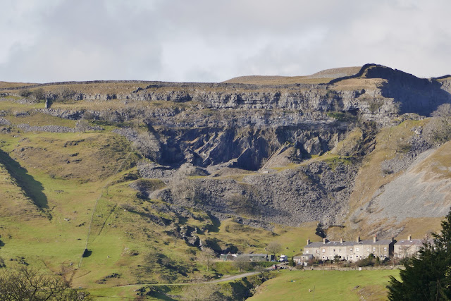
Foredale quarry, a mile or so further on - contains the famous 'unconformity' where horizontal layers of Great Scar Limestone rest on basement siltstones and Horton flagstones of Silurian age. You can see the division here quite clearly. The line marking the separation of the two rocks marks the former surface of the earth for over 70 MILLION years before the limestones were laid down in a shallow tropical sea when we were basking somewhere near the equator. Think of that and wonder how miniscule our own little lifespans are.
You can't go along Ribblesdale without getting a pic of the Lion of Ribblesdale, can you? It annoys me now that many walkers abbreviate her to PYG. That lovely old name abbreviated to three bloody letters! Mr Wainwright must be turning in his sleep up on Haystacks at the very thought ..! I'm with you, Alf, lad ...
How can you mess with the name of this beauty? The 'Hill of the Winds' she always will be.
Now then: Selside is a place that doesn't often get photographed as there is nowhere to park and folk are usually rushing to get to the showpieces. It is a place I love even as much as Settle. The building with the old Queen Vic letter box gets me every time. Marie Hartley and Joan Ingilby, in their classic 'Yorkshire Dales', mention that Selside once had a 'town hall' which 'now looks more like a derelict barn' and was once a 'gathering place for the men.' I'm assuming this distinctive building is the one. Far cry from Leeds town hall, isn't it? There was once even a tiny school here for 15 children (see it behind the phone box?) - and a Cheese Fair held every year on 24th June!
The colours of this ancient 'village' - both natural and man-made - are a welcome relief from the dull browns of the surrounding moorland. Selside's name comes from the old Norse, meaning 'sallow shieling' - or 'the farm by the willows'. It was a small Norse settlement at the time of the Domesday Book.
I also love this ancient ash tree and the view beyond it to Penyghent.
As English here as you can get. How out of place would bluetooth be? You get the feeling, when you're this remote - that even the post is a novelty.
Those colours again. In Selside, everything looks about to topple over. It's marvellously quaint.
The tiny village is nationally famous, of course, as the home of Alum Pot. My legs weren't even up to the walk up to it today, so I wandered round the buildings with my camera - only you never see a soul here to give you funny looks.
Beyond, on the left, we reach the wilds of North Ribblesdale and the 'basket of eggs' topography of the famous drumlin field.
These cute, smooth, asymmetircal hills with one long side and one blunt side - are always aligned along the axis of moving ice and are clearly associated with glaciers, but there are as many theories to how they formed as there are drumlins in England. I was always taught that sluggish ice bulldozed material over boulders, but ...
These bovines are still discussing it! 'It wasn't those big ones that you did a few years ago, was it, Daisy?
As we reach Ribblehead, we see the lower half of the beautiful Thorns Gill, flashing silver in the landscape.
Then the biggest of the three comes into view: Whernside, at 2419 feet. This view to me, in a car, usually means only one thing ...
Food! And at Ribblehead there is usually a brilliant bacon butty van - or plenty of nice brown grass if you're vegetarian. There's also the great view of the 24 arch viaduct, built in dreadful conditions in the late 19th century ...
Brew time view as I munched a butty half way down Chapel-le-Dale, thinking 'it's great to be back' - and I'll show you my next stop tomorrow. Nighty night!
Stephen x


Thank you Stephen. Wonderful to take a photo tour of our most wonderful of vacation spots. We travel to the Dales of Yorkshire from Canada each year. And each year we are advised We should branch out and see the other parts of England. And all we say to these people is, "why?". 😊
ReplyDeleteI fully understand. I've been all over the UK and to my mind nothing can compare. Thanks for the comments! Have a good explore of the site, and you might enjoy the Dales Rocks website too! Best regards, Stephen
Delete