Chapel-le-Dale (Settle to Ingleton Triangle Part Two)

Having topped up the tank at Ribblehead (mine - not the car's!), I drove down Chapel-le-Dale feeling, as ever - all nostalgic. With views of Ingleborough opening up like the one above - I was well and truly hooked in ...

A few miles south of Ribblehead, just past the old school house, this enticing lane opens up on the right. I first turned down this old Roman road as a seven year old back in the seventies, and have been captivated ever since.

The lovely former vicarage of Nether Glen, backed by Ingleborough, is one of the most painted scenes in the Dales. The mountain sits like an extinct volcano on its plinth of limestone and looks much bigger than its 2337 feet would suggest.

Nether Glen is everyone's dream home - but even greater delights lie in the vicinity.

The exquisite little church of St. Leonard was built in the mid 16th century at an important meeting place of several routes, when the dale was known as 'Wyersdale' or 'Wiersdall'. Interestingly, it lies close to an area of ancient activity where the nearby caves and potholes may well have had significance for early pagans - as did the summit and lower slopes of Ingleborough. Hurtle Pot - behind the church, was the reputed home of an infamous boggart.

The porch is a relatively recent addition.

There are two graveyards, on each side side of the lane. Christopher Francis Drake Long (1902-24) the discoverer of White Scar Cave, lays at rest here. He died in suspicious circumstances just a year after his great discovery. Suicide was suspected; his great goal having been achieved, for him, perhaps too early. He was prone to bouts of depression.

Weathercote is a fine old country house not far from the church, and reached by a gated lane from the main road. Until recently it was the home of the late Mrs Mary Bazeley, who died at the grand old age of 108. She attended church, remained active until her final year and even baked her own bread. I corresponded with her when I was writing 'A Three Peaks Up and Under' and met her on several occasions. Weathercote just doesn't seem Weathercote without this amazing lady. I still have her immaculate, hand-written letters which are like a work of art in themselves.

The house now has a new owner. The magnificent cave in the grounds was the first ever showcave in the Yorkshire Dales - until 1971, when a caver was killed by a falling rock. This tragedy meant the cave was closed to the public, though Mrs Bazeley did allow walkers and botanists access with special permission.

The current owner has a placed a sensible warning. 'Steep drops and deep water - enter this site at your own risk.' You never know, one day - he may re-open the cave for visitors. There were no hard hats, waterproofs and wellies for the countless Georgian and Victorian tourists who descended into the depths.

The impressive Weathercote Cave - more correctly a pothole - is 180 feet long, 45 feet wide and nearly 100 feet deep. It is split in two by a bridge of rock. This was probably the original entrance to the cave before roof collapse exposed the open hole that we see today. Visitors could either be satisfied with a view of the waterfall from the 'bridge' - or descend a series of steps and clamber underneath for an awe-inspiring spectacle: the finest above ground in the Three Peaks, described by Harry Speight as 'without rival in England.' I often wonder if ancient man knew this cave as the open pot we see now - or if it was covered 4000 - 5000 years ago. Surely it must have been of great significance.

This is a view of the bridge from the west side, showing the moss covered limestone. In exceptional floods the entire hole fills to the brim and overflows down the valley past the house!

The bridge viewed from the lip of the shaft on the north-west side. Here it can be seen how a visitor must scramble down the boulders of a collapsed ceiling to reach the bottom of the hole.

Weathercote Cave from the opposite side to the house - showing a normally dry stream channel on the left which is only active in times of flood. Turner sat beneath the wall (in the background) to paint the cave in flood in the early 19th century. Wordsworth was also captivated.

This is the point where the normally dry stream channel plunges into the pothole in high flood. An unusual picture from an angle I haven't seen before.

The old entrance to the cave, from inside the perimeter wall. Visitors in the 1960s paid 6d at the house for a key. Back in the 30s the owner even offered ham and eggs to visitors. I remember Mrs Bazeley handing me the ancient key (it was huge and very old) and I was thinking 'wonder if Wordsworth and Turner held this?' Wishful thinking!

For the first time ever - a life line has been tied onto a tree, so now it is much safer to descend the crumbling steps, many of which have been washed away by flooding over the years.

The steps are steep and the line is a welcome aid to the descent. No doubt they were once in pristine condition.

On the descent, several side passages are noticed. Here, tufa is forming on the moss as the lime rich water trickles from a small cave.

The walls show evidence of former floors to the cave, dating back many thousands of years. A fine example can be seen in the centre of this picture.

The heart races with the sheer cacophony of sound ahead, as a peep under the bridge reveals the column of white water streaming into the cave. Note the flood debris rammed into the crack just right of top centre.

The bridge itself is a mass of fault breccia. A fault is reason for this pothole's formation, as water rushes from one bedding plane, falls down a fault guided joint, and once again disappears underground.

Close up of the structure of the bridge.

Emerging at last from the bridge - after watching every footstep - we are met with the 77 foot waterfall in all its glory, and the massive wedged boulder known as Mohammed's Coffin; further evidence of roof collapse. The water sinks into masses of cobbles and continues its underground route to God's Bridge, at the base of the limestone.

This is, in my opinion, the finest waterfall in the Yorkshire Dales - and I've seen them all. Yes - even better than Hardraw and Thornton Force; even better than Catrigg and Aysgarth. It is the unique situation that makes it special. This is like a scene from The Lord of the Rings. The combination of depth, moss covered limestone and grotesque 'faces' in the walls of the shaft, coupled with incredible sound and vibration, really serve to numb the senses. It's an absolute classic.
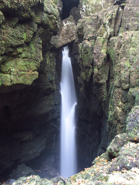
This is a view in better light from a few years ago. Look at that grumpy old fella to the right of the fall! And can you see that sleepy chap on the left with the rather blunt looking chin?

Today, though, it was a bit dull weatherwise - and the spray in the air made photography difficult. Come here just after mid-day in the sun, and a superb rainbow arches over the scene; something I'm aiming to capture on camera. See the tree trunk wedged above Mohammed's Coffin? ...

Well here it is from above, looking 100 feet down into the shaft. The flood that moved that tree trunk must have been incredible. It hasn't moved for several years now.

Leaving the adrenalin behind, we encounter far gentler views in the vicinity. Weathercote is a botanist's heaven.
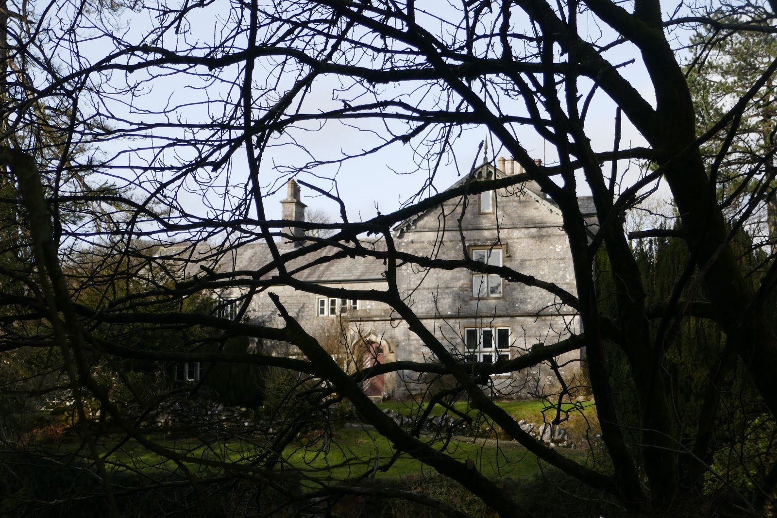
Peeping through the trees at the lovely old house. What would you give to live here?

The flora at Nether Glen is usually equally impressive.

Back at the church for a look at the millenium plaque to the many who lost their lives building the Ribblehead viaduct.

There's another one inside the church.

St Leonard's is beautiful simplicity. You've got to see it.
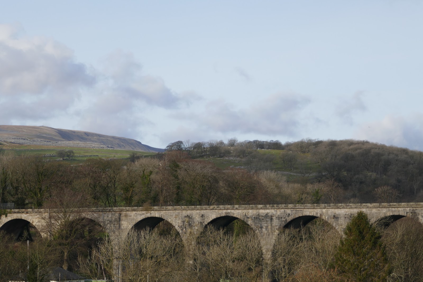
Finally it was into Ingleton. This is the long disused viaduct that brought travellers in the early 19th century for the first time. They would take carriages to Weathercote Cave ...

Inglesport for a well earned brew after all that climbing about in holes!

The quaint little main street of Ingleton with the 'old sweet shoppe' - another 'must visit' if you get chance.

And finally, Ingleton Church - where Wainwright famously met Betty for his first date! A church built more or less on the line of the South Craven Fault, which explains problems with the foundations, and the steep drop taken by the road alongside into the valley below.
See you again soon
Stephen x
No comments:
Post a Comment