The Nooks and Crannies of Newby Moss

Hidden on the bleak southern slopes of Ingleborough are some of the most interesting, if daunting, features of the mountain: a series of shafts and holes that are seldom visited ... but likely to remain etched in the memory once they are. This is a wander on pathless terrain for the limestone connoisseur.

I began at the small hamlet of Newby Cote, having parked in a convenient layby on the lane between the village of Newby, and the hamlet itself. This place has a 'time stood still' atmosphere.

There are some lovely, rustic views - with the hamlet having altered very little over the centuries.

A track - the only distinct one of the day, leads northwards behind the farms, reaching a wall-end at this old lime kiln; a picturesque spot.

From then on there is nothing but a sombre landscape - Newby Moss - where the limestone is covered by glacial till. No paths, no walls .... no people .... no mobile phone reception. This place is a wilderness.

It does, however, have its occasional rocky highlights. Check out this limestone giant, dropped by a melting glacier.

This one, however, is an erratic - a huge hunk of 'Grassington Grit' most likely plucked from the upper reaches of Ingleborough and deposited here on Newby Moss.

Here it is from another angle. Note the delicate colour contrast with the limestone.

Another view, this time looking south east over the erratic to the escarpment of the South Craven Fault, and the basin of the Craven lowlands beyond.

On occasions the limestone pops out where the glacial till or 'boulder clay' has been weathered away. This has itself been, at one time, a more extensive area of pavement. It looks like a place fit for a meeting. Choose your favourite stool ....

Another gritstone erratic contrasting with the white limestone in the foreground. Newby Moss may be barren, but it offers up these kind of delights regularly. The white limestone 'giant' we shall visit next can just be seen in the background, left of centre.

A wonderful tapered boulder of limestone on Newby Moss, with heavy rain thundering into distant Ribblesdale behind. Penyghent is in the centre.

The contast this time is the other way round. The large boulder is of limestone, hemmed in by smaller Silurian rocks. All have been dropped by the glaciers at the end of the last ice age, some 12000 years ago.

This view of the limestone boulder is particularly magnificent.

And here it is from the north. The lack of sun on this side means the rock is deeper in colour, but still stunning.

A wider perspective of the boulder, isolated on the moor, with Plover Hill, Penyghent and Fountains Fell all looming behind.

This monster, bigger than a car, was noted in Wainwright's Walks in Limestone Country as being wrongly marked by the Ordnance Survey, who refer to it as 'Harryhorse Stone.' Yes, A.W., I fully agree. The map-makers got it wrong, and you will see why very soon. Nevertheless, this is a cracker!

A rear view shows grooving caused by rain running off the gentle slope of the boulder. It's easy to climb up and be King of Newby Moss for a few minutes. Don't worry, you can shout 'I'm the King of the Castle.' No-one will hear you unless you're very unlucky.

A large slice of limestone has fallen from the boulder leaving a weathered recess. In this view, the 'stadium' of Crummackdale can be seen at top left.

This is an old grouse shooting butt - and no, folks, that's not a giant sheep and lamb in the centre just beyond. That's Harryhorse Stone, and what a delightful feature it is.

He even has his own foal, but to me looks more likely to go 'baa' than 'neigh.' What do you think?

From the back, Harryhorse Stone looks even more realistic. 'Come on,' he's saying to the little one, 'Let's get away from this annoying bloke.'

When he does face you, however, he's quite a cutie! The limestone is really weathered and delicate, as this rock is exposed to some of the wildest weather in England.

'Smile please, Harry.' A splendid portrait of the horse's moss-covered countenance!

Just beyond Harryhorse Stone, newly formed shakeholes like this one are the first indication that all is not settled beneath. After all, we are on Ingleborough.

The first of the 'big' holes just north of Harryhorse Stone is P2a, which swallows most of the stream running down from Ingleborough's Yoredale slopes, as it meets the Great Scar Limestone. The stream, Grey Wife Sike, used to flow much further down Newby Moss, and has found its way into P2a relatively recently. As a result, a dry stream channel can be seen cutting its way down the hillside south of Harryhorse Stone.

Grey Wife Sike cascading into P2a - the first water seen on our journey so far, and one of the highest stream sinks on Ingleborough.

Grey Wife Sike, running on its final stages towards its sink at P2a. The slopes of Little Ingleborough rise beyond.

Moving briefly east of P2a, this large doline is reached with the stream bed active only in heavy rain. Cavers have attempted several digs in this hole.

Newby Moss Pot lies nearby, walking along the same contour just to the east. First explored by the Gritstone Club in 1968, it has a squeeze down between boulders and cavers have done much work stabilising the entrance.
Newby Moss Pot in motion ....

The entrance climb looks a bit daunting to say the least. The pot eventually drops in a series of pitches to a depth of 96 metres.

This photograph of the shakehole containing Newby Moss Pot gave me the jitters. I didn't see another person all day on this wander, yet there's a man in red on the picture above ... and zooming in ... if you can spot his legs you've better eyes than me. I'm one for ghosts, you know, but this is a bit creepy ...

Another view of Newby Moss Pot from the west, showing the rock bridge in the bottom, and the reinforced banking of boulders guarding the small entrance to the pot.

Moving further east still, this is the entrance to P2b. Wire netting stops inquisitive sheep from exploring too closely. Cavers have again tried to connect this pot laterally to the others on Newby Moss, but a boulder prevented much progress.

Returning west, just beyond P2a, which was our first pothole of the day, is this fantastic, recently discovered shaft. It has been reinforced by scaffolding and hours of work have been put in, trying to link the pots and find the Newby Moss Master Cave, which is believed to be hiding somwhere below. This barren wilderness could yet hide Ingleborough's greatest secrets.
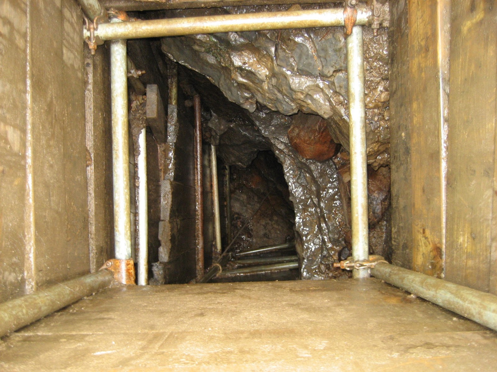
The shaft is a credit to the hard work, skill and determination of those who wish to discover uncharted territory. Think of the effort needed to cart that lot up to this remote spot.

Moving west, things begin to get really exciting as we meet the most famous potholes of Newby Moss. This one, The Fluted Hole - also known as the Fairy's Throne or Raspberry Pot, has been described by Wainwright 'as attractive as it is possible for a pothole to be.'

Fluted columns of limestone protrude from the depths. It is only 43 feet deep at the most, but appears to be much more.

From the south, the stream can be seen entering the Fluted Hole at the north-west corner, slyly hidden under a wedged boulder - as can be seen in this picture. Trees, shrubs and ferns decorate this wonderful limestone garden.

Here the wedged boulder can be seen in close up. Stride across at your peril .. as one slip would send you to the floor of the pot ... and never be tempted, as I once saw a sheep do - to use this boulder as a bridge!!

From a short distance to the west, the fluted hole is shyly hidden. All the potholes on Newby Moss are like this. They reveal themselves only at the last minute. Walking on here in mist must be risky business.

In close-up, the Fluted Hole shows attractively grooved rock architecture.

The Fluted Hole from the north, showing the rich arrangement of ferns and mosses. It was first explored by the Yorkshire Rambler's Club in 1904, and is actually the highest shakehole (above sea-level) on the Great Scar limestone of Ingleborough, at an altitude of 457 metres.

A short walk to the west are the fabulous Pillar Holes. This is a series of beautifully carved shafts. One of the strange features of the Newby Moss potholes is that they descend to great depths, but none has any really significant horizontal development. That is, once you've abseiled down, you have no more caving to do. How then, were they formed? Possibly a combination of glacial meltwater and minor faulting did the trick - but there is still much to discover about this intriguing area.

The Pillar Holes show the Newby Moss pot holes starting to get serious. They drop to a total depth (in stages) of 87 metres and at least one of the entrance shafts is a sheer 43 metre (130 feet) drop. With care, you can clamber onto the 'pillars' and peer down into the depths.

The highlights are these spectacular 'pink' pillars of carved limestone, giving the appearance of looking down from the balcony into the nave of a great cathedral ... only nature shows even better craftsmanship.

The view is a totally unexpected surprise on the barren wastes of the moor and is truly magnificent.
A delicate spray of water showers the colourful walls of the shaft ...

Pillar Holes, looking north to Ingleborough, with Little Ingleborough on the right. From here, it's another 800 feet or so to the summit.

A delicate grooved column inside the shafts of Pillar Holes.

A large limestone pedestal allows a terrific view down the central shaft.

Some creatures don't care about pillars, or heights - just a perfect spot to set up home.

Moving further west, a cluster of still more potholes is reached, including Moss Hole and Fern Pot, but nestled cunningly in the group is the 'biggy.' This is Long Kin West - by far the deepest of the potholes on this side of Ingleborough, and without doubt one of the most dangerous places in Britain for the unwary. This grass-covered rock bridge carries an old packhorse route from Cold Cotes leaving two 'small' shafts on either side. Small? The hole on the left - maybe three feet wide at the top, is an incredible 292 feet deep!

Long Kin West is also known as the 'L' hole, due to its resemblance to a capital of that letter. 'Hell' would be more fitting. It merely illustrates the dangers of walking on Ingleborough after dusk, or in heavy snow.

A caver's own image of an intrepid descent of Long Kin West. The author has, needless to say, never been brave enough. It leads to a boulder choke at the bottom, and may have even greater depth if these boulders could be removed.
(source flickr.com)

Another view of the bridge over the deepest part of Long Kin West.
The golden rule with potholes is to never throw down stones. However, there are no ways in to Long Kin West at the bottom, so if there is no rope dangling down, you can safely drop a stone and begin counting. I've waited something like 8 seconds before I've heard a 'ping'. The trick is to let the stone fall straight down, without touching the sides; not an easy task. Take extreme care at the entrance to this hole. Wainwright, in fact, wrote cheerily that, 'if life is considered precious, keep well away.' He was right. Use common sense, keep dogs and children well away, and you can enjoy this wonderful place.

By walking north west from Long Kin, the eccentrically-named 'Boggart's Roaring Holes' are reached, just beyond a nasty peat bog. They were nameless until a husband and wife team, Robert and Margaret Balderston, penned their 'Ingleton; bygone and present' in 1888. They used a plumb line to measure the depths of the potholes on their beloved Ingleborough, but on throwing stones down this one, noticed they seem to go far beyond the line, and that strange 'roaring' sounds issued up from the depths, leading to a name Tolkein would have been proud of.

Boggart's Roaring Holes have remarkable variation. This one, the 'Wet Hole' has four short pitches inside, dropping to 37 metres (over 100 feet) and is good practice for cavers using ladders forthe first time.

The middle hole, with the customary thorn bush, drops to 61 metres down three pitches and is again great for novice ladder climbers.

Boggart's Roaring Holes: looking across the middle hole to the north hole.

The north hole itself has two small waterfalls plunging into the depths. It is yet another spectacular spot on Ingleborough. Surely no mountain in the UK can equal its interest?
A view down into the impressive north hole.

Wonderful contrasting colour view of the north shaft of Boggart's Roaring Holes.

Boggart's Roaring Holes, looking north to a cloud covered Ingleborough.

The Yoredale slopes of Ingleborough, with the landslip of Falls Foot (top left) and the till-covered limestone benches south of White Scars, leading onto Newby Moss.

Majestic Whernside, seen across Chapel-le-Dale from Boggart's Roaring Holes.

Whernside - zooming in for a close-up view.

Two of the peaks, Whernside (left) and Ingleborough, frame Boggart's Roaring Holes. The big grassy mound at centre may well be the Boggart himself. His face is in profile - a dark slit of a mouth, prominent nose and blinking eye, with a tuft of Bilbo Baggins hair made up of the rushes on the extreme right. Use your imagination and he's there indeed!

Newby Moss and Ingleborough Common are separated from White Scars by the prominent valley of Crina Bottom.

Returning on a low level route across Newby Moss - and meeting life at long last.

Just to remind you - some of this life is .. er ... perhaps best avoided!

Gorgeous view of a ewe ... with the lowlands beneath, beyond the uplift of the Craven Fault.

View back to the hamlet of Newby Cote: another world.

Completing the day at the Hill Inn. This was a spectacular view of Ingleborough, swirled in light cloud.

Whernside trying its best to compete, across the valley. It doesn't quite live up to the master.

Most welcome man-made feature of the day.

Dales through and through ... waiting with drooling tongue for fodder.

'Cheers!'

Newby is the village slightly left of centre at the bottom of the image. Drive up Henbusk Lane and there is a layby on the right about half way up. Just to the north-east lies the hamlet of Newby Cote. Go through this and follow the path up to the moorland of Newby Moss. The 'necklace' of potholes can be clearly seen where the Yoredale beds meet the Great Scar Limestone. There are no distinct paths on the moss, so choose a day with clear visibility. Enjoy the wander ... and it's great fun trying to identify the many potholes and sinks. A copy of 'Northern Caves' volume 2 adds greatly to the enjoyment.
Stephen x
Marvellous descriptions and photos Stephen. A thoroughly enjoyable read
ReplyDelete