Ancient Footsteps
Uncovering the past around Ribblehead

Ribblehead has much more than its 24 arch viaduct. I have visited the area scores of times over the past few years, and, on each occasion, have revealed something new and spectacular.

Here's the main magnet of course, the great viaduct across Batty Moss - with Whernside dominating the surroundings. Notice the upland plateau just beneath the summit - the product of a 'niche glacier' during a cold period at the 'melting' stage of the last glaciation. A prominent landslip can also be seen on the mountain, filled with shadow just left of centre.

History is everywhere here. These mounds are all that remains of the 'hospital' built to serve those who toiled on the viaduct between 1870 and 1875 - when smallpox and other diseases were rampant (for full details of the construction camps -see my earlier post on the Shanty Towns of Ribblehead).

Harry Speight, in his famous Craven and North West Yorkshire Highlands (1892) provided this serene illustration of a fox sheltering in a double stone circle. My mission today was to set out and locate this 'lost' antiquity. Speight's directions mention going down the road from Ribblehead and looking over the wall 'on the right.' Mmmmm! That leaves several options, and many historians today think he actually meant to say the 'left' .... so let's have a closer look!

The field on the left, as the road heads down towards Ingleton, contains a range of features such as this small ring cairn, with just a few stones left in its south west sector.

It is interesting that small boulders of gritstone - remnants of erratics left by the glaciers, have been deliberately chosen for the construction.

This is the same barrow viewed from the west, just visible in the centre of the image, with Penyghent and Park Fell. These barrows are very close to the Viking settlement at Gauber, located at the top left of the photograph. However, they are more likely to be Bronze Age.

On the opposite side of the road - the right hand side when moving towards Ingleton, things get even more fascinating. The field is a mass of small 'clearance cairns' - where Bronze Age peoples cleared fields for cultivation and livestock by piling the boulders into these irregular mounds. The clearance cairns may well surround prominent burial cairns. This one is considerably larger than most around it and appears to have been disturbed.

Here's another view of it, forming a horseshoe shape similar to the enclosures on the summit of Ingleborough. Following Speight's instructions in his classic book, this would appear to be the area he mentions ... but these cairns are small and there is no evidence of the double ring he mentions.

Within this field of 'clearance cairns' - some of the gritstone erratics seem to me to be too strategically placed to be in their original positions when the ice melted. This one, at north east, appears to be lined up exactly with another at the south west of the enclosure. Were these placed to coincide with the rising and setting sun? Notice how this boulder is exactly in line with the dip in the hills above which the sun would have first appeared in June.

A good example of a clearance cairn - a stark example of early farming practice.

This one stands out as something a bit more special. Those gritstone boulders have definitely been arranged in an arc around a prominent central mound.

The field is full of intrigue. You can smell and feel the past here.

Limestone is never far away of course, such as here at Ellerbeck Rocks.

Speight mentions a broken limestone pavement with a massive detached boulder of gritstone at the north-east corner and its long axis pointing down the dale. Could this be it? If so, we are in the vicinity of his great double circle. This is one beautiful erratic.

I took a wander further south where evidence of cairns was even more prolific.

Immediately obvious in this field is a prominent tongue of land on a raised plateau, containing the fabulous Haws House Pasture Ring Cairn, easily seen on aerial photographs like this one. A range of barrows and cairns can be found towards the tapering north east section of the plateau. Was this Harry Speight's circle, and has it been robbed of stones since the latter part of the 19th century? It is certainly on the left, and close to a limestone pavement as he describes ...

Here I am approaching the plateau from the south. The Ring Cairn is up there somewhere - very well hidden.

Got it at last - and yes - you can see evidence of a double ring here. No doubt about that.

This is an amazing place. The banking of the Haws House Ring Cairn is about five feet thick with just a few stones present. A gritstone boulder is again placed at north east as an 'outlier' and standing in the centre of the circle it is exactly in line with the rising sun. The boulder can be seen at top left.

Another superb view of the Ring Cairn.

Close up of the banking structure of the Haws House Ring Cairn.

Now I'm lined up due north at noon. Notice the boulder placed in line with the sunrise position? I might be wrong - but it looks a definite strategic placement to me. Either that, or the circle was placed with the boulder's natural position in mind.

Here's the stone itself - and it contains a series of grooves in its surface.

The stone - looking west towards the lower slopes of Whernside.

Panoramic view of the Haws House Ring Cairn, possibly 3000 years old.

The cairns along the plateau have smooth profiles and appear to be associated with the main Ring Cairn, rather than being the result of clearance. This is a lovely example.

The same cairn, looking west.

Looking back along the Haws House Pasture with the Ring Cairn visible just above centre and the outlying stone to the right.

A closer inspection of the cairn and its outlier, with a great view of Whernside with a touch of snow on its northern slopes. (SD752782)

Across the road is what many consider to be Speight's 'lost circle' - the massive Neolithic Cairn in Sleight's Pasture.

This splendid cairn fits with Speight's description, but did he mix up right and left in his writings?? This lies on the left hand side of the road, and not the right, as Speight stated. It has a raised banking and has been obviously disturbed, with an open end facing Whernside. Possibly the mountain had symbolic significance to the builders.

The Sleight's Pasture Cairn, looking west.

Evidence of a definite double ring structure.

Is this a possible excavated barrow incorporated into the banking?

The superb Sleight's Pasture cairn looking north east, with some of the large gritstone boulders on the left.

A good view of the northern section and the remains of the 'double ring', with Park Fell in shadow.

Overall, this is still a very impressive structure, despite the amount of destruction over the years.

Whernside and the Sleight's Pasture Neolithic Cairn. I still can't decide which was the Harry Speight circle!

The search for the 'Lost Circle' as seen from the air ...

Beyond, at Fell Close Rocks, the natural architecture is superb.

This limestone duo have real character. Note the prominent landslip on Whernside.

Looking north west from Fell Close Rocks.

The boulders in a wider panorama.

Whernside from the limestone pavement at Fell Close Rocks. The slopes of the Yoredale Series can be seen plunging down to meet the Great Scar Limestone.

Whernside framed by lonely trees.

Whernside's upper slopes contained a dusting of snow today.

A weathered limestone boulder dropped by the melting ice 12,000 years ago.

Man versus nature. The Ribblehead Viaduct and a cracking boulder, left by melting ice.
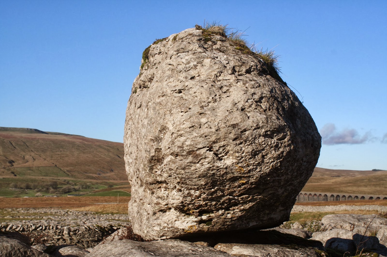
A dominant presence!

Looking towards Gearstones, the wooded ravine of Thorns Gill - and the abandoned hamlet of Thorns itself, in trees on the right.

View of Whernside from the path to Colt Park Wood.

Gorgeous view of Whernside's snowy northern slopes - above the upland plateau carved by the niche glacier. The barn sets off the scene to perfection.

Colt Park Wood is sheep-free, and a perfect example of what limestone might have looked like before farming. The Frog Prince has been guarding the perilous foliage-covered grykes for thousands of years. He was dumped by the great Ribblesdale glacier.

And he's been grinning cunningly, ever since.

'Read it? Read it?' ... Well you nearly have ....

But he looks great from all angles.

As does the living symbol of the Yorkshire Dales ...

The glaciers have left their handiwork everywhere, such as here at New Close Rocks.

The vivid oranges of autumn bracken contrast beautifully with the limestone.

Pointing to a blue heaven, with Penyghent competing.

New Close Rocks - a sea of colour.

And completing our ancient tour with a visit to the fabulous Viking Longhouse at Gauber.

The kitchen is equally impressive. Not exactly 'fitted'!

A quick pop into the Blacksmith's ....

And a last peep through the door of the Longhouse - with the light beginning to fade.
Enjoy wandering in this marvellous ancient landscape ... but respect all monuments, tread with care and be sensitive to the age of these special sites. You'll love the adventure!
Stephen x
I enjoyed reading this. Thank you.
ReplyDeleteGreat post, thank you.
ReplyDelete