The Watlowes
Malham's Meltwater Marvel

The land between Malham Tarn and the Cove is a mass of Great Scar Limestone lying between the North and Mid Craven Faults. Weaknesses in this limestone running from north to south were exploited by meltwater as the ice began to slowly thaw towards the end of the last glaciation (13,000 - 12,000 years ago). Looking at this picture, you can see where the main meltwater channel flowed while the ground beneath the surface was still frozen solid. The water had a momentous journey, flowing in a great torrent down here ...

... and then cascading over the edge of here! Malham Cove was, of course, Britain's greatest waterfall - higher and more spectacular than Niagara. But all that lies in the distant past. It is now over 150 years since flooding was so horrendous that water flowed over the edge ...


The author can occasionally let his enthusiasm get the better of him. Here he is, poised on the overhang at the exact spot that the water once cascaded over the edge of Malham Cove. Use common sense and don't try to replicate this picture.

Some idea of the massive drop taken by the water, as it rushed down theWatlowes valley and plunged down the face of Malham Cove. This is a late evening shot -when you can have the Cove to yourself.


Apologies for a touch of camera shake - but this was a case of 'hold out the camera with one hand ... press the trigger ... and .... celebrate survival!!'

What would you give to see this waterfall in action once again?

Nowadays the water, nearly a mile to the north, simply disappears into the limestone here at Watersinks. In flood, it does flow further and further down the Watlowes valley - but it has never been bad enough for it to make it to the Cove since that last momentous occasion. If ever there is a reason to wish for grand scale flooding, this is it! It's common sense to see that such a small stream would have struggled to form a huge valley like the Watlowes - but remember we are talking about melting ice sheets. There would have been an awful lot of water!

It is strange that, to the east, there is another meltwater valley - that of Gordale Beck, before it drops momentously into Gordale Scar. This one, however, still has the beck flowing through it and the water, luckily for us, hasn't found its way underground yet. Geologists believe that the deposits of travertine or tufa, caused by chemical processes in the water, have blocked the fissures beneath to prevent this from happening. The depth of the Gordale meltwater valley indicates how much water must have been at work here!

Back to the Watlowes ... and the best way to explore it is to walk up from Malham Cove, or, as I did, park at Langscar Gate, on the steep Cove Road out of Malham. Here, a path runs down the fields to the Watlowes valley - sometimes simply called 'The Dry Valley.' There is no gradual build up to the Watlowes. This place is amazing from the word 'go' ...
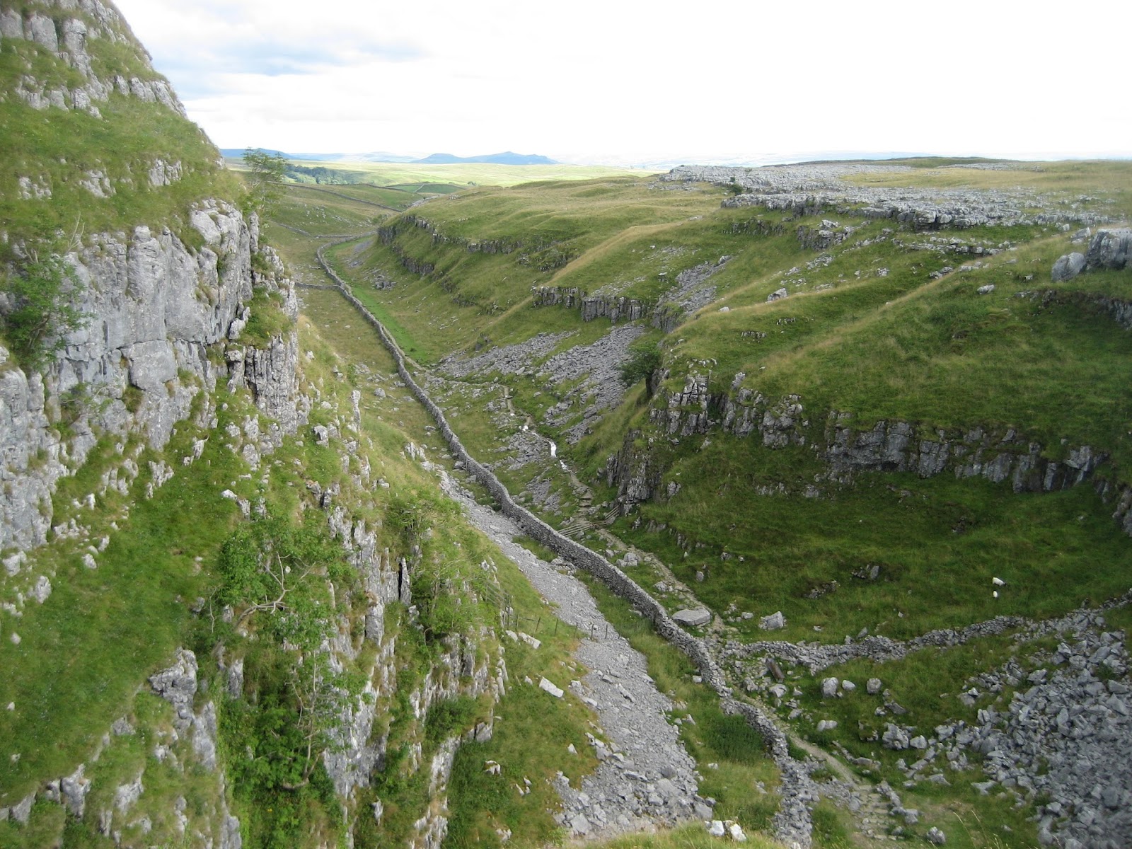
The path meets the Watlowes at another well known dry waterfall and this effectively divides the valley in two. The upper reaches, behind the camera, lead down from Malham Tarn, while the view here is south towards Malham Cove. The fact that the entire area was covered by moving ice sheets is indicated by the exposed pavements up on the right, some of the finest in the Malham area.

There are several small caves in the cliffs of Combe Scar to the east of the dry waterfall.

Almost as if the water has only just left us - here the final stages of the channel can be seen before the water plunged over the now dry waterfall at Combe Scar.
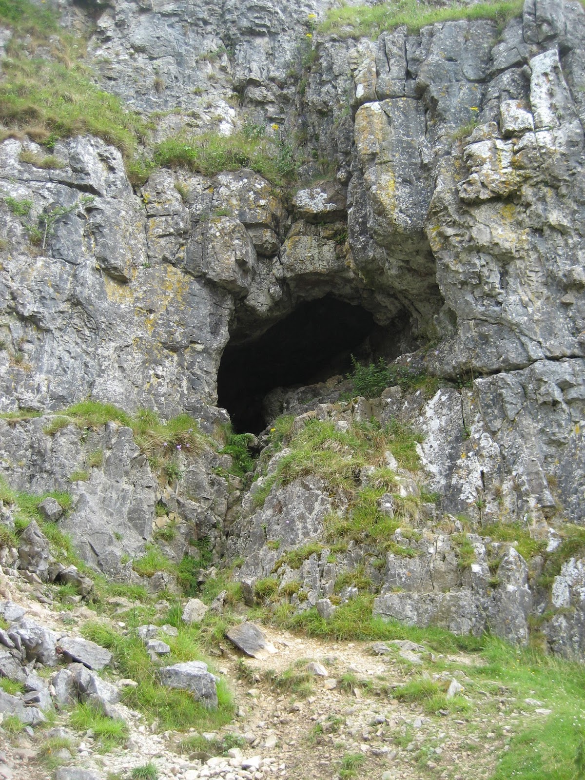
Langscar Cave is the most prominent cave entrance on the eastern flank of the valley above the dry waterfall. It has produced human remains and no wonder - it is a very convenient shelter. Meltwater will once have flowed out of here before the lowering of the valley, and the course of a former waterfall is obvious.

Looking out of Langscar Cave after a careful scramble into the entrance. Note the large amounts of scree caused by freeze-thaw action.

A wider perspective of the view out, looking across to the path through the upper reaches of the Watlowes valley.

From deep within: Langscar Cave is an excellent natural shelter from the elements with some lovely rock sculpture.

The back of the cave is choked with sediment and has much potential for archaeologists. Objects left by the people of today are much less welcome. I emptied cans and bottles out of here and left it looking as it should. Malham deserves better.

A spectacular late afternoon view of Langscar Cave on the eastern side of the Watlowes dry valley, with the smaller caves beyond at the head of the dry waterfall.

Beyond the cave, just to the north, it is possible to scramble up onto the top of Combe Scar for some dramatic views which get better with every step forward ...

Here, I have scrambled up the east flank and am looking north west along the upper reaches of the dry valley. In flood, water manages to come this far down before sinking near to the dry waterfall.

A beautiful weathered section of limestone pavement on the crest of the scar, with another fine example on the left of the photograph, on the far side of the valley. The Craven lowlands can be seen in the distance, south of Malham village.

Bird's eye view of the magnificent Watlowes valley, making its way down to Malham Cove. This kind of view can only be gained by wandering off the beaten track, but it's well worth it. What a place to sit in silence this was ...

Fantastic rock architecture, moody skies and a wonderful limestone landscape. This is my idea of a perfect situation.

Climb up to here and you'll surely agree.

Each and every step shows something new. There is so much variation. Several authors have belittled the Pennines when comparing it to the Lake District, but I have to disagree. This inclined pavement is stunning both in colour and form.

My main reason for the scramble up to these heights was to visit something very special indeed. Look carefully in the centre of this sheltered valley and you'll spot it.

This beautifully preserved and excavated Bronze Age House is one of the secret wonders of the Malham area. Only small fragments of pottery and a few flints were found from a time when people in lowland Britain were largely working with metal. This indicates that the people who lived around Malham during the Bronze Age lived in absolute poverty. The situation of this house is idyllic: living here would have been anything but.

Details of the northern wall of the house. The width of the slabs would have been ideal for supporting posts and roof timbers. This site was excavated by the great dalesman Arthur Raistrick (1896-1991), a man who had a passion for geology and archaeology, and who rarely wasted a moment of his long life. His books on the area are classics of their kind.

Several of the stones have been deliberately chosen with hollows into which supporting posts would have been jammed.

The Bronze Age peoples took advantage of slipped rocks in front of the scree (extreme left centre) to create a passage entrance to the dwelling which can be clearly seen on this picture.

A general view of the Comb Scar Bronze Age House, showing the sheltered position on three sides. In the centre of the house, covered by a small stone, there is a post hole 15 inches deep and 9 inches across which would have supported the roof of the dwelling. The entrance passage, utilising the scree, can be seen on the right. I am assuming only those with a real interest would scramble up to this remote position. As Arthur Raistrick wrote, never be tempted to add stones, or to remove them - and think of future generations who will want to enjoy this wonderful spot. To eat a sandwich here and to think you are sitting where man will have eaten nearly 3000 years ago is a humbling experience.

View from the upper reaches of Comb Scar to the Watlowes, and the fine limestone pavement on the other side of the valley. It is a wonderful undulating landscape.

The typical terraced landscape created by Gordale Limestone above Comb Scar, with grassy ledges and aprons of scree. The frequent bedding planes contrast with Cove Limestone seen further down the valley at the great cliff of Malham Cove.

Smooth clints, fashioned from the upper reaches of the Gordale Limestone, contrast with the grassy slopes of the Watlowes valley beyond.

There are many settlement remains on the western side of the Watlowes. This view across picks out, just left of centre, the outline of a tiny dwelling on a prominent knoll.

Peering off the edge of Comb Scar, with a natural rock garden to add to the beauty.

The tremendous towering landscape of crags and buttresses which dominate the view at the edge of Comb Scar. The dry waterfall runs down the cleft in the immediate foreground.

The figures give a sense of scale.

About to descend precarious cliffs - looking north to the meltwater channel, still active to this point in times of high flood.

Returning to those caves we saw at the beginning of the adventure - only this time I'm above them. I didn't risk crawling along that ledge. It's a long way down.

A chaotic jumble of boulders where the former meltwater channel meets the lip of the dry waterfall: in many ways a smaller version of the head of Gordale Scar.

The awesome drop down the dry waterfall from a precarious position!

Nearby is the spectacular detached limestone pinnacle of Ing Scar Crag.

I have now crossed the valley onto the western side and am descending the slippery steps to examine the dry waterfall from beneath.

The approach to the dry waterfall, with the prominent entrance to Comb Scar Cave - for rock climbers only. My earlier shot down the dry waterfall was from the highest grassy terrace way up there! The 'waterfall' has been formed on a minor fault within the Craven Fault zone.

Portrait of the dry waterfall. You can almost imagine a great cascade tumbling down what is, in effect, a miniature Malham Cove.

There are plenty of hand and foot holds and it is, in fact, not a very difficult climb for the experienced.

Lets say goodbye - and leave these two in peace. What a place to live, ladies - I envy you!

Malham Cove is at bottom right. To explore the Watlowes, either walk up the dry valley from the Cove - or, for a quicker route, park in the layby at top left, just beyond where the road crosses a prominent wall. Here, a path goes east along the fields before traversing the scars above the dry waterfall. The Bronze Age house is marked on Ordnance Survey maps as a 'hut circle' and is hidden in the horse-shoe shaped valley to the east of the scars. It is a tough scramble up with sensational views. The Watlowes deserves a detailed exploration. Don't rush it. As with all places, treat it with respect and remember that archaeological sites are protected by law. Touch nothing and enjoy the privilege of being there among the ancients!
Stephen x
No comments:
Post a Comment