Malham Tarn
Vanishing Waters and Visual History

During the Carboniferous Period which began some 340 million years ago, the great movements of the Craven Faults caused many unusual things to happen to the landscape around Malham. The land above (to the north) of the North Craven Fault was lifted upwards along the fault line, while that to the south was 'downthrown' in comparison. This is easily seen by going to Malham Tarn, where the limestone cliffs of Great Close Scar lie hundreds of feet above those in the Watlowes valley a mile to the south. The limestones around the Tarn have been cut back so severely by ice and water erosion from the fault line (roughly where the clump of trees are in the picture) that a bed of impermeable basement 'slate' has been exposed to the surface. Since the last ice age this has held a unique natural upland lake, fed by lime-rich streams; the beautiful Malham Tarn.

The famous Water Sinks. Here the difference in height of the two layers of limestone can be seen clearly. The limestone hill of Great Close rises over the (hidden) tarn in the left background, while here the outflowing water from the tarn rushes over the till-covered slate and meets the 'downthrown' limestone (far below Great Close) - vanishing at once into the boulder-choked fissures. The 'vanishing river' is one of the great natural wonders of the Malham area and dye tests have proved the final destination of its journey. Only a tiny amount goes to Malham Cove, while most makes its way to the east of Malham and pops out to the south - at Aire Head Springs.

Water Sinks from the air. The stream can be seen vanishing at centre. In flood, the passages below the surface fill up quickly - and the stream sinks further and further down the Watlowes valley - though it has not been known to make it over the top of Malham Cove since the middle of the 19th century. What a sight that must be!

Before my exploration of the Tarn, I set off to find the water's destination - just south of Malham village. This view is of the attractive Mires Barn, with Cawden reef knoll on the left, and the enticing valley of Gordale Scar at centre.

About two miles south of Malham Tarn, Cawden and Gordale Scar are features of the Mid Craven Fault, the line of which cuts just above Malham village from west to east. It is largely responsible for all that awesome scenery! These fields lie on Bowland shales that have formed on top of the downfaulted limestone, which lies hundreds of feet below the surface. In simple terms then, the faults have caused the limestone beds to lie in three gigantic 'steps': the highest being behind Malham Tarn, the next at Malham Cove, with the bottom 'step' lying beneath these fields. The power of nature indeed!

The infant River Aire beginning its long journey through Yorkshire just south of Malham. Where has all that water suddenly appeared from?

The answer lies here - at Aire Head. Remember that vanishing stream at Water Sinks? Well, here it is again, some two miles downstream, popping out of the Great Scar Limestone onto the Bowland shales. Its journey, from the Tarn to here, remains a complete mystery. Nobody knows if there are huge cave passages involved - or the amount of twisting and turning that the water undertakes on its journey. It's amazing to think of the water's secrets when you see it emerging from here ...

Aire Head in close-up. Within seconds of emerging it is rushing down the fields to meet Malham Beck (the water emerging from the Cove) to form the River Aire.
A short clip of the emerging water ...

It must be wonderful to emerge into the daylight after that long tortuous journey underground.

Standing above the resurgence at Aire Head, and watching the water emerging at the base of the limestone. Remember there is much limestone buried below, of course, but it has been covered by a layer of shale.

Aerial view of Aire Head. The point of resurgence is in the centre of the image, where the emerging channel runs roughly left to right before a right angled bend and short journey down to Malham Beck. At top right, Gordale Beck, having tumbled down Gordale Scar and Janet's Foss, makes its way into the main channel too, with the three streams effectively becoming the River Aire.

On the drive up to the Tarn, I peeped over the wall to the unmissable Malham Cove. Here, my camera is roughly on the line of the Mid Craven Fault, which lies about 500 metres downstream of the Cove itself. The great cliff has been cut back from the fault line over thousands of years. In the foreground can be seen the ancient lynchets where the fields have been terraced; these examples are believed to be some of the oldest in the area, and may date back to Celtic times.

Another famous resurgence. This is the base of Malham Cove, where the water emerges into daylight after a largely unknown trip from the Smelt Mill Sink to the south west of Malham Tarn. However, some of the water from Water Sinks does make it here too, while some of the Smelt Mill water makes it to Aire Head! It is a very complicated picture and it seems there are linking passages underground between both main channels that only become active in times of flood.

A diagram showing the main sinks around Malham. The Water Sinks stream is assumed to curve around the east side of the village before emerging at Aire Head. Water goes to the Cove from a wide area to the west, including Pikedaw and Gorbeck.

The Smelt Mill Sinks to the south west of Malham Tarn. The Smelt Mill chimney can be seen above centre. A stream on the left passes underneath the road before sinking beneath glacial drift into the Great Scar Limestone. This is the main source of the water that emerges beneath Malham Cove. Its route and nature, after about 600 metres from the Cove face, remain a complete mystery.

The Smelt Mill Sinks in close-up. The stream can be seen making its way across the drift covered slate and meeting the Great Scar Limestone, causing it to promptly vanish before making its trip to Malham Cove. The drop to the Cove is considerable, so there could be huge underground shafts and waterfalls that man has never laid eyes upon ....

There is a small 'dry valley' below the sinks. In high flood, the water disappears further and further down this valley. It can be seen heading off to the right.

The chimney of the Smelt Mill which operated from 1815 to about 1860. Galena (lead sulphide) was brought here from the mines at Pikedaw to the west. Its position was determined by a close source of peat for fuel, and a good water supply for washing the ore. Galena was 'roasted' on top of a peat fire to a temperature where the lead separated from the sulphur and flowed out of the firebase as molten metal.

A close-up of the Smelt Mill Sink vanishing beneath the glacial drift into the limestone - next to be seen at Malham Cove - where it emerges as Malham Beck. In flood, more and more of the water mysteriously begins to emerge at Aire Head. Spooky!
Watch it disappear ...

Plaque attached to the Smelt Mill Chimney. It is well worth a visit.

The Smelt Mill Chimney with Great Close Scar and the limestone plateau behind Malham Tarn, visible in the distance.

The flue of the Smelt Mill would have originally have been covered over and served two purposes: firstly it was used to blast air up by using bellows - and secondly it reduced pollution by allowing lead in the flue gases to condensate on the walls. This was invariably scraped off and added to the lead produced by the smelter - so all in all it was a useful device.

The remains of the Smelt Mill are clearly visible on this picture. Beyond lies Great Close Hill and, in the background, the vast limestone plateau known as the Malham High Country.

Close-up of the Smelt Mill ruins - a superb example of industrial archaeology on Malham Moor.

A first view of the beautiful waters of Malham Tarn from the west side. Here, waters running off the high ground of Fountains Fell have formed an important area of acid peat bog known as Tarn Moss. It contrasts in colour with the lime rich grasslands of Great Close Hill, beyond the tarn itself. If, in the imagination, you picture the cliffs of Great Close extending across the entire picture, it gives some idea of how far the limestone has been cut back from the North Craven Fault, which lies to the right of the image. The Tarn lies on a bed of slate and has a natural dam of moraine along the south side, effectively 'bulldozed' there by a glacier.

Limestone scars along the west side of Malham Tarn are associated with settlements beyond, and one very special cave ...

Chapel Cave has been fully investigated as recently as the 1990s. The earliest finds date back to Mesolithic (Middle Stone Age) times and it is believed it was used as a hunting shelter for game inhabiting the fringes of the tarn. Remains of fish (perch) have also been found, as well as objects from both Roman and Medieval periods. This is a cave with a long story - like everything else in the Malham area.

Close-up of Chapel Cave entrance. It is named after a supposed chapel that lies on the moor nearby. There were several of these religious hide-outs in the Malham area during the Dark Ages.

The cave is very special for another reason: it is a stronghold for the magnificent cave spider Meta menardi. This massive arachnid is one of the biggest and rarest spiders in the country. It is a privilege to see it this close. The spiders can bite if disturbed, but who would want to wake her up when she's this comfy? These amazing creatures are photophobic when adult, yet the youngsters enjoy the light, an adaptation believed to encourage the spread of the species. Note the beautiful silken egg-sac hanging as a work of art from the cave roof.

A glance to the back of the cave shows a jumble of fallen boulders in chaotic confusion.

Rock architecture inside Chapel Cave.

The bizarre roof formation inside Chapel Cave, which I call the 'Hand of God'. The hand appears to be grasping the head of a poor, hooded lady on the left of the image.

Wedged limestone boulders inside Chapel Cave.

All the while she barely moved .... thankfully!

Through the eyes of a caveman: peering out of the entrance to Chapel Cave, which looks out over Malham Tarn.

Another view from the entrance. No doubt early man would have spotted a tasty morsel or two from this position.

Chapel Cave is well hidden on this scar, to the west of Malham Tarn.

An interesting peat pool on Tarn Moss. The Field Studies Council organise many superb outdoor activities in this area, including pond dipping and exploring the many flower, moth and bat species. The tarn is owned and protected by the National Trust - and no wonder ...

The special peat bog environment of Tarn Moss. Recently, a superb re-cycled plastic 'board walk' has been placed across the moss to allow a close-up inspection of this unique habitat.

The clean air of the limestone country encourages a fabulous range of lichens to flourish on the trees of Tarn Moss.

A view of Tarn Moss from the boardwalk, looking across to Highfolds Scar and the grounds of Tarn House.

Malham Tarn from Tarn Moss, with the cliffs of Great Close Scar prominent behind.

Looking south across the shallow waters of Malham Tarn. It is the highest alkaline natural lake in England, at 1229 feet above sea level, and considered of world importance as a habitat. No boating or swimming is allowed for a good reason. The tarn harbours rare stoneworts as well a colonies of the white-clawed crayfish.

Walking along the north shore of Malham Tarn, some of the views through the tree canopy are very impressive.

Another glimpse of beauty through the canopy.
Taking in the expanse of water ...
Taking in the expanse of water ...

This dead branch, in shadow, provided a great contrast to the sun-drenched waters of the tarn beyond.

Malham Tarn House was originally built in its remote location as a shooting lodge by the Lister family, on the site of an older dwelling. In 1852 it was bought by James Morrison who gave it a Georgian style, but it is best known as the home of his son, Walter, an eccentric millionaire who lived here for 64 years until 1921. Morrison was a Liberal MP who spent much of his life giving away huge sums of money for various causes, as well as entertaining all and sundry at his 'mountain home'. Prominent guests included Charles Darwin ... but it is, of course, Charles Kingsley with whom the house is most associated. Malham Tarn House is the dwelling where Tom, of the Water Babies, saw himself unclean in the mirror .. and Walter Morrison was the model for John Harthover. After coming here, you will want to read the book, as I did. Today there was a craft fair in progress. It's usually much more lonely ...

Beyond Tarn House, the woodlands give way to open grassland and the rounded summit of Great Close Hill, with its important Iron Age burial chamber. The prominent, 'mother' like curve of this hill may have been important to early cultures.

Tucked behind the woodlands of Highfolds Scar are two archaeological wonders. This dwelling, 15 feet long and 9 feet wide, is known as the 'Priest's House.' Both Celtic and Anglo-Saxon objects have been uncovered here, mostly influenced by the work of that great dalesman, Arthur Raistrick. The main Celtic find was a circular brooch-like head, with gold inlay and split into four quadrants. Later objects included bronze articles identified as book edging and the tag of a book marker. The finds were similar to those in the Anglian monastery at Whitby, and it is believed this was the cell of an Anglian priest or hermit from the seventh or eighth centuries. As with all sites of this nature, it should be left undisturbed - as it was found.

This is the doorway to the Priest's House, at the south-east corner.

The surrounding walls, filled in with rubble, have obvious hollow sections which may have been chosen deliberately to support posts across which the roof was arranged.

Some idea of the thickness of the walls can be seen in this image.

The main living space of the Priest's House consists of an enormous limestone slab making up the western flank. The house is divided into three by small partition walls.

The Priest's House is well hidden and sheltered from all sides. It would have been a perfect spot for a secretive life.
Let's step through the front door of the Priest's House ...
Let's step through the front door of the Priest's House ...

Just beyond lies the remains of a medieval farm. This was probably abandoned after the land was taken over by the monks of Fountains Abbey in the late eleventh or early twelfth centuries.

The walls of the farm seen in wider context. These isolated moors were those traversed by Tom the chimney sweep in the Water Babies, when, with the sound of church bells ringing in his head, he wandered towards the waters of Vendale (Arncliffe) situated over the Malham high country.

The farm is split in two, with half of it having a paved floor, beneath the turf, of limestone blocks. This half, at the rear, has a gravel floor below which much pottery was found.

A view of the farm with the entrance at the south-east corner.

The southern wall of the farm building, seen covered with turf in the foreground, is wider and has a curved outline.

Highfolds Scar seen from the east, with the woods of Malham Tarn House below. A view from Great Close Hill.

Malham Tarn seen from the ridge leading up to Highfolds Scar.

The impressive shelter-cairn on the summit of Great Close Hill - Malham Tarn's dominating height - covers an important Iron Age burial chamber. This may cover an earlier site dating back as far as 2000BC. The position of Great Close Hill, surrounded as it was by water on three sides (Great Close Mire has now been drained) and with prominent 'curves', may have had some cultural significance for these early peoples. The proximity to a lake at such an altitude will have also played a part in its location. Hundreds of flints have been found on the shoreline surrounding this sacred hill.

The circular shelter is good protection from the wind, but I wouldn't fancy sitting in there today with all those nettles for company. To the south, just visible in this image, each end of a line of boulders can be made out, known as a 'linear feature', and found on other similar burial sites in Yorkshire. Its purpose remains unknown.

Coming down off Great Close Hill, the last remnants of the once extensive Great Close Mire are reached. This was another lake, adjacent to Malham Tarn. Beyond the wall is the huge pasture of Great Close itself, site of the former Malham fairs of past centuries. It is one of the largest enclosed pastures in Britain.

Just off the south-east corner of Malham Tarn is the fascinating Seaty Hill tumulus. This conical hill has a low mound at the summit, 66 feet across and surrounded by a ditch.

The thistle-covered tumulus has one or two 'kerb' stones remaining. It actually consists of two mounds, an earlier Bronze Age construction being topped by an Iron Age mound.

Two holes had been dug by ancient man into the top of the lower mound. In the north-west hole a seated skeleton was found, carefully placed with its knees drawn up, and facing another skeleton to the south east. Round the edges of the site, in saucer-shaped depressions, were some 13 other burials, usually of incomplete skeletons, three containing coloured beads and one with blue glass fragments. The sacred nature of Great Close Hill is obvious from this position and there may well have been some link between the two.

History is everywhere in the Malham area. This view to the east from Seaty Hill tumulus shows the ancient Monks road of Mastiles Lane bisecting the moor. If you look carefully on the background green field, just above centre and having a corner level with the white boulder on the right - a huge but faint rectangular ditch can be seen crossing the moor an lying either side of Mastiles Lane. This is a believed to be the site of a Roman Camp that would have been used for a short period when the Romans were crossing the moor.

The massive rectangular camp is best seen from the air - though I can't afford a helicopter.

The greatest find at Seaty Hill, however, was made here, where one of the 13 subsidiary burials lay more or less over the main Bronze Age example. Here a skeleton was found with a sheep-bone whistle or pipe wedged carefully between the knees. Also, an iron knife was discovered, and there were hand and wrist bones from other skeletons surrounding the main burial. Were these to play the pipe in the next life?


Back to nature on the southern shores of Malham Tarn - and here the outflow from the lake can be seen having its last journey over the till covered slate before meeting the limestone.

Glancing north, to the impressive Great Close Hill and Scar, with Highfolds Scar to the left.

The waters leaving Malham Tarn. Tarn House can be seen in the trees in the distance, on the far side of the lake. To the left, part of the terminal moraine barrier that holds back the waters of Malham Tarn can be seen clearly.

Bye bye water! The enigmatic Water Sinks, where the stream sinks into the limestone, beginning its trip to Aire Head - where we began our day.
See it for yourself ...

A final view of the vanishing water. Tea is beckoning!

The ancient farmstead of Trenhouse south of Malham Tarn: this is a 17th century house built on a much older site dating back to the Vikings. Hus being Norse for a small settlement with trani being Norse for 'wild crane.' This, then, is the 'settlement of the wild crane', a bird no longer found in this area.
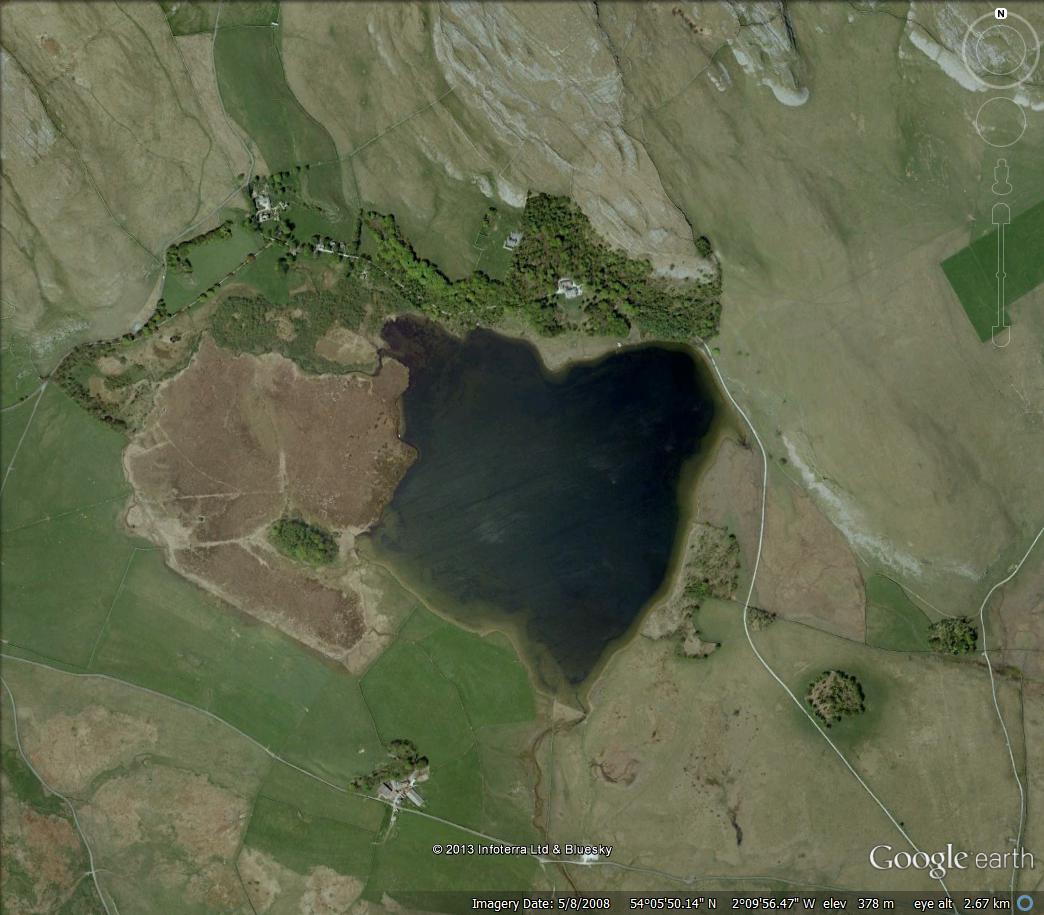
Malham Tarn from the air. The large brown area to the left of the water is Tarn Moss. Tarn House can be seen clearly in the trees north of the lake shore. The cliffs of Great Close Scar are on the right, with the Iron Age tumulus just visible on the summit. Parking is available at Water Sinks (bottom centre) and in the quarry area just to the west of Tarn Moss. Take a map and explore this wonderful place.
It is an offence to disturb or damage archaeological sites. Ancient monuments are protected by law. Please treat them with the greatest respect and leave investigations for those with expert knowledge. In all areas around Malham Tarn, please do your best to cause as little disturbance as possible to this precious and unique environment.
Stephen x
This is a fascinating article and thank you
ReplyDeleteYour knowledge and love of Yorkshire shines through. We have shared this on our blog and thank you
Many thanks for that, Gill and Geoff. It's great when you can click a button and go anywhere you want on the limestone. I love your Land of Enchantment page too. Some great history on there.
DeleteAbsolutely fantastic Stephen.
ReplyDelete